ASTANA – Recently discovered maps reveal new layers of Kazakh statehood, suggesting it could be 12 centuries old, said Mukhit-Ardager Sydyknazarov, Kazakh researcher, doctor of political science and director of the Institute of Modern Studies at the Gumilev Eurasian National University, in an interview with Kazakhstanskaya Pravda newspaper.

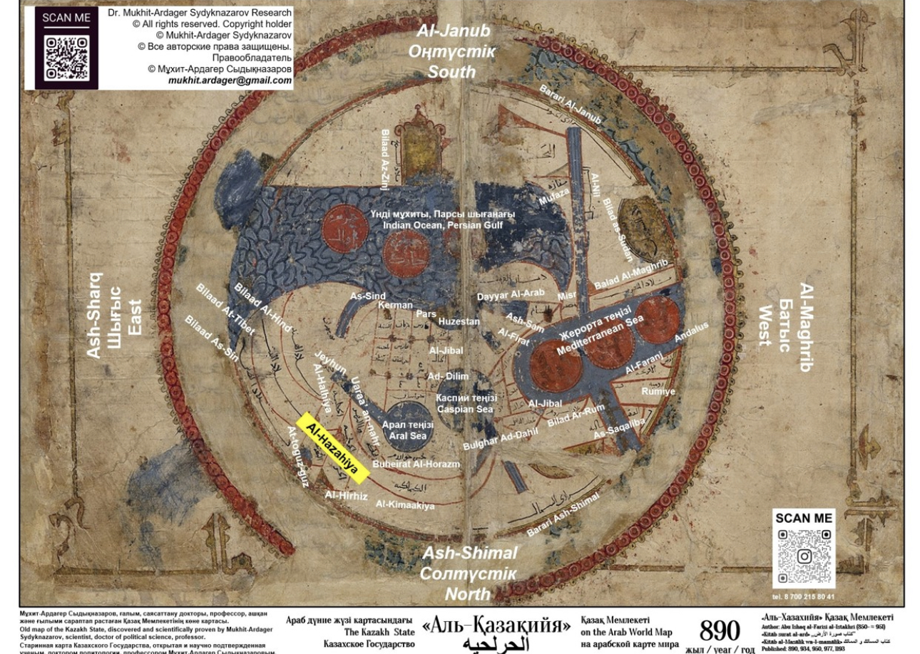
State of Al-Hazahiya on Al-Istakhri’s world map. Photo credit: egemen.kz
This new discovery comes against the commonly accepted notion that Kazakh statehood dates back to 1465, when Kerey and Zhanibek sultans drifted away from the Uzbek Khanate, seeking autonomy.
Sydyknazarov has dedicated 20 years to cartography, time traveling through European and American maps to study the origins of the Kazakh state. In recognition of his work, he was honored with the appointment of Goodwill Ambassador by the Kazakh Foreign Ministry.

Mukhit-Ardager Sydyknazarov. Photo published on egemen.kz
“For almost 20 years I have been engaged in research of historical cartography of the Kazakh state. During this time, I found, described and systematized more than 4,000 ancient maps of the Kazakh state, as well as maps of other Turkic states, such as Azerbaijan, Kyrgyz, Turkmen, Uzbek states, and Türkiye, in national museums, archives and royal cartographic collections of Europe, the United States, Middle East and Asia,” said Sydyknazarov.
“Most of them are Western—European and American—depicting the Kazakh state from the 9th to the 19th centuries, along with some from the 20th century. A large number of eastern maps drawn and written in Arabic script were also found,” he added.
During those years handling Turkic and Arabic maps, he found many Kazakh polytonyms (state names), such as Qazaqia, Cassackia, Cassackia, Қазақия, Kazakia, Kassakia and ethnonyms (nation’s names), such as Qazaq, Cassak, Kassak, Қазақ, Kazak.
“The earliest Arabic map of the world with the indication of the Kazakh state was created in 890. The maps clearly, accurately and unambiguously show that the Kazakh state is known under the ‘Kazakiya’ polytonym in various phonetic and orthographic variations of the Arabic language, such as Al-Kazakiya, Al-Kazagiya, Al-Kazalgiya, Al-Khazalgia, Kazalgia, Al-Kazakiyya-min-al-Atrak, Kazakiyya-min-al-Atrak (Kazakiyya, which is Türks), but at the same time sounding as close as possible to the autopolytonym and autoethnonym qazaq,” said Sydyknazarov.
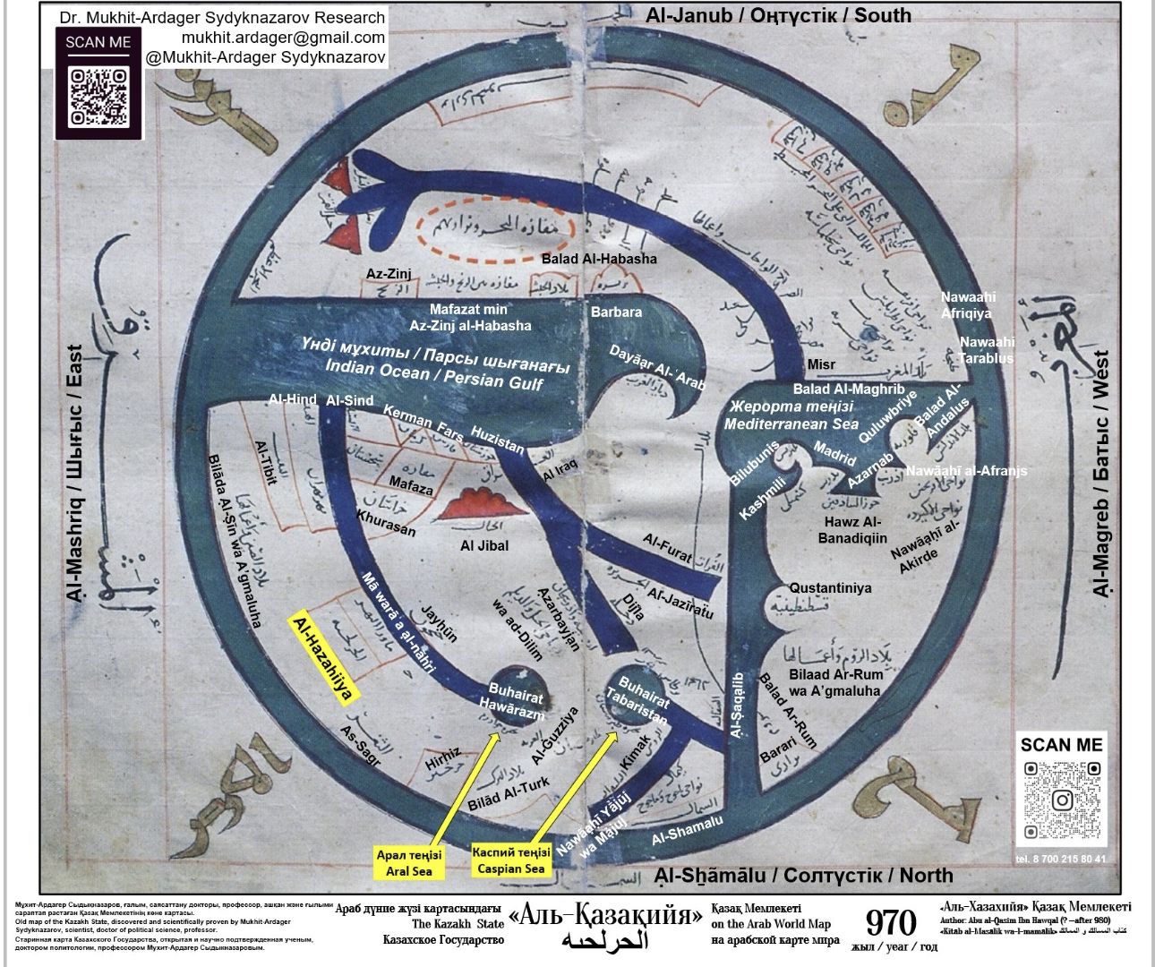
The map’s author was the cartographer Abu Ishaq Ibrahim ibn Muhammad al-Istakhri (850-951). It is featured in Al-Istakhri’s “Kitāb al-Masālik wa-l-mamālik” (The Book of Roads and Kingdoms), an atlas-like work that was a major ninth-century scientific achievement, republished in 934, 950, 977, and 1193. Maps from these editions are preserved in libraries across Türkiye, the Middle East, Europe, and the United States. The map studied by Sydyknazarov is part of the cartographic collection of Leiden University in the Netherlands.

Al-Hazahiiya state on Ibn Haukal’s world map of 970. Photo credit: egemen.kz
“A huge amount of work has been done. We have retranscribed and transliterated a huge array of maps in Arabic script, showing them in Latin and Cyrillic, providing explanations,” told Sydyknazarov to Kazakhstanskaya Pravda.
The newly discovered maps challenge the existing concept that the statehood of Kazakhstan dates back to 1465.
“We’ve all been raised on this concept from school to university. I, too, genuinely believed in it and conducted my research accordingly. So, what do we do now? My answer is this: with new evidence and newly researched written sources, the current understanding of Kazakh statehood and Kazakhstan’s history compels us to revise the existing supporting structures,” said Sydyknazarov.
Ethnogenesis, or the formation of Kazakh statehood, along with the fundamental institutions of the Kazakh state, was largely established by the 9th-10th centuries — long before the conquests of Genghis Khan and the empire he formed in the 13th-15th centuries, according to him.
“Kazakhs entered the confederal (and⁄or federative) empire of Genghis Kagan, having temporarily delegated the geopolitical subjectivity of the Kazakh state along with the decision-making process to the center of the confederation of Genghis Kagan’s empire for only two centuries—the 13th and 14th,” said Sydyknazarov.
“According to the theory of contingency, otherwise known as the theory of continuous statehood, periods of confederation, periods of colonization or colonial dependence, periods of governments in exile do not weaken, but rather strengthen a particular individual state,” he added.
The majority of Kazakh clans are documented in written sources and folklore dating back to before Genghis Khan’s empire, up to the 13th century. These Turkic and Kazakh clans formed the foundation of Turkic states depicted on 9th–12th century maps.
Sydyknazarov’s book “Uninterrupted History of Nationhood in Kazakhstan. The Kazakh State on European and American Maps of the 16th-19th Centuries. Atlas,” which includes 130 maps dating from 1562 to 1879 was first published in 2023. This September in Brussels, an expanded second edition was published, featuring 200 maps with detailed author descriptors and map translations.
“I plan to include around 100 Eastern maps from the 9th–14th centuries that identify the Kazakh state in a separate book,” said Sydyknazarov.
