
Editor’s Note: The Astana Times continues its Forgotten Cities of the Silk Road series, exploring Kazakhstan’s tentative UNESCO World Heritage sites. In this edition, we turn to Otyrar, once the capital of a flourishing oasis, a center of Islamic scholarship, and a frontier stronghold that witnessed both prosperity and destruction. Mentioned in 9th-12th century Arab and Persian chronicles and tied to the dramatic events of the Mongol invasion, Otyrar offers rare archaeological insights into urban life, trade and water management along the Fergana-Syrdarya Corridor.
Other nominated sites within the Fergana-Syrdarya Corridor include Asanas, Kyshkala, Sauran, Yassy-Turkistan, Zhankala, Zhankent, Syganak, and the Zhetyasar oasis settlements.
ASTANA — Long before it was laid to ruin by the Mongol invasion in 1218, the ancient city of Otyrar had already cemented its place as a vital cultural and commercial stronghold in southern Kazakhstan. Known for its sophisticated urban planning, monumental architecture and far-reaching trade networks, the city played a defining role in the rise and resilience of Silk Road civilizations across Central Asia.

Otyrar Tobe. Photo credit: RWTH publications Click to see the map in full size. The map is designed by The Astana Times.
At the confluence of the Arys and Syrdarya rivers, the Otyrar Oasis stands at a point where several of the historical Silk Roads, a vast network of trade routes facilitating cultural and technological exchange from as early as the 3rd century B.C., converged. It also lies at the transitional zone between the traditionally sedentary south and the nomadic north of Central Asia. For both geographical and historical reasons, the oasis, located approximately ten kilometers west of the Timur train station in the Turkistan Region, is considered crucial to understanding Kazakhstan’s layered heritage and its place in the broader regional context.
Covering approximately 200 square kilometers, the largely uninhabited oasis landscape features the remains of six ancient towns, known as tobes (hills) in Kazakh, along with a 2,000-year-old system of irrigation canals. The main site, Otyrar Tobe (1st to 19th century A.D.), is accompanied by Kuyruk-Tobe, Altyn-Tobe, Pshakshi-Tobe, Mardan-Kuyk and Kok. Excavations at Otyrar, first launched in 1969, revealed a classic Central Asian urban layout with a citadel, shahristan (town center), rabat (outer suburbs) and earthen fortifications.
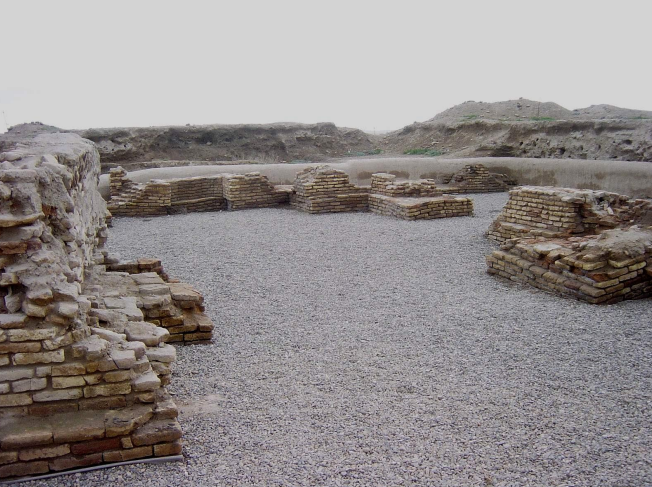
The Mikhrab area of the later Mosque, showing completed masses, retaining walls and gravel surface. Photo credit: RWTH publications
While once naturally preserved by layers of sand and silt, these remains are now increasingly vulnerable to erosion from wind, rain and increased visitor traffic.
The Otyrar settlement sits atop a large pentagonal mound, aligned with the cardinal directions, with its highest point reaching 18 meters in the southwestern section. Measuring roughly 400 meters on its western edge and 380 meters on the southern and northeastern sides, the site remains partially enclosed by remnants of fortification walls and towers, particularly visible on the northeastern and eastern flanks. A surrounding moat further highlights its historical defensive infrastructure.
Historically referenced under various names such as Farab and Tarban, Otyrar rose to prominence as the capital of an extensive oasis region home to more than 200 preserved historical and cultural heritage sites. The city is frequently mentioned in the writings of medieval Arab, Persian, and Turkic scholars, including al-Tabari, Maqdisi, Ibn Hawqal, and Hafiz Tanish. According to the 10th-century geographer Maqdisi, Farab boasted a population of approximately 70,000 men and featured a citadel, a Friday mosque, bustling markets and artisan shops.
Otyrar first appeared in written sources in the early ninth century, already recognized as a city. In 1218, it reappeared in historical chronicles in connection with the Mongol invasion of southern Kazakhstan. Though devastated, the town gradually revived and went on to become one of the most significant administrative, political, trade and craft centers of the region.

Irrigation system. Photo credit: RWTH publications
Architectural remains from the Timurid era (14th–15th centuries), such as city gates, towers, palaces and mosques, reflect the fusion of local traditions with architectural styles from Central Asia and Iran.
Otyrar’s strategic location at the crossroads of key caravan routes contributed to its prosperity. Trade networks connected the city eastward with Taraz, Balasagun in modern-day Kyrgyz Republic and the eastern part of the Turkistan Region; southward with Merv, Nishapur, Kabul and India; northwest with the Aral Sea and Ural Mountains; southwest with Khorezm across the Kyzylkum Desert; and westward with the Volga region, North Caucasus, the Black Sea coast and Byzantium.
The city also distinguished itself with an exceptionally preserved irrigation system dating from the 1st to the 18th century. This system included canals, dams, sluices, and traces of irrigated farmland where melons, gourds and other crops were cultivated, offering a rare glimpse into medieval agricultural engineering in Kazakhstan.
Following the Mongol conquest, Otyrar, along with other devastated cities such as Sairam and Syganak, experienced a resurgence fueled by renewed international trade. Numerous public amenities, including bathhouses, workshops and mosques, were constructed. Archaeological excavations have unearthed significant remains from the 16th and 17th centuries, when Otyrar was part of the Kazakh Khanate. Among these is the cathedral mosque built during the reign of Timur.
Today, the ancient city of Otyrar holds the status of a site of national significance. It is protected and curated by the Otyrar State Archaeological Museum-Reserve, established in 1979, which continues to oversee research and conservation efforts.
Kazakhstan is also home to components of the Volga-Caspian Corridor of the Silk Roads, which includes the ancient settlements of Kyzylkala, Saraychik and Zhayik.
Additionally, the Silk Roads: Early Period (Prehistory) nomination includes the necropolises of Besshatyr, Boralday and Esik, which showcase Kazakhstan’s ancient roots well before the Silk Road era.